Library Record
Images
Metadata
Title |
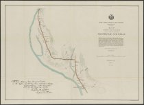
Map showing the location of the highway between Northville and Wells |
Author |
Locke, C. G. |
Digital File |
View high-resolution map image on New York Heritage database. |
Published Date |
1897 |
Object Name |
Map |
Control Number |
2018.011.0850 |
Call Number |
Map 0850 |
Publisher |
New York State Land Survey |
Physical Description |
color print encased in mylar, 31 x 23 inches |
Summary |
Color map of the area just north of Northville, where East Stony Creek meets the Sacandaga River. Includes note from assistant surveyor C. G. Locke to Verplanck Colvin. "Station Map No. 9, Series II." See also maps 2018.011.0835-0853. |
Search Terms |
New York (State). Adirondack Survey.; Northville (N.Y.); Wells (N.Y.); |
Imagefile |
181\20180110850.JPG |
Notes |
Transcript of verso: Sacondaga River Sheet 9 of 6-12; AA.181.6j |
Web Rights |
http://rightsstatements.org/vocab/NoC-US/1.0/ |
Collection |
General Map Collection |