Library Record
Images
Metadata
Title |
New York Land Survey. Franklin County Township No. 24, Sheet No. 6. |
Author |
Colvin, Verplanck, 1847-1920 |
Digital File |
View high-resolution map image on New York Heritage database. |
Published Date |
1890? |
Object Name |
Map |
Control Number |
2018.011.0840 |
Call Number |
Map 0840 |
Place of Publication |
Albany |
Publisher |
New York State Land Survey |
Physical Description |
color print encased in mylar, 36 x 26 inches |
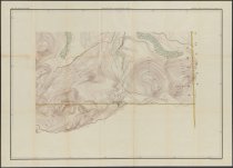
Summary |
Color map of area around Mount Von Dorrien and Alford Mountain in Franklin County. "Philosopher's Camp Road" labeled, as well as "Deserted Shanties called Turner's Headquarters". See also maps 2018.011.0835-0853. |
Search Terms |
New York (State). Adirondack Survey.; Franklin County (N.Y.); |
Imagefile |
181\20180110840.JPG |
Notes |
Transcript of verso: Mt. Von Dorrien No. 6; 63.163.30 |
Web Rights |
http://rightsstatements.org/vocab/NKC/1.0/ |
Collection |
General Map Collection |