Library Record
Images
Metadata
Title |
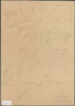
Map of State lands in the Warrensburg Tract and Goldthwaite Patent, Town of Warrensburg, Warren County showing the initial point in Crane's Line of Mile Trees, called "Totten & Crossfield Base Line," as relocated and monumented by Verplanck Colvin in 187 |
Author |
Holmes, J. E. |
Author added entry |
Davis, Albert T. |
Digital File |
View high-resolution map image on New York Heritage database. |
Published Date |
1932 |
Object Name |
Map |
Control Number |
2018.019.0125 |
Call Number |
To29 |
Publisher |
Finch, Pruyn and Company, Inc. |
Physical Description |
24 x 34 inches |
Summary |
Map of intersection of the Towns of Stony Creek, Thurman and Warrensburg, west of the Hudson River at Ferguson Brook. Many notations describing landmarks for property lines. J. Ross Patent and Goldthwaite Patent indicated. |
Search Terms |
Lumbering--New York (State)--Adirondack Mountains.; Paper industry.; Warrensburg (N.Y.); |
Imagefile |
184\20180190125.JPG |
Notes |
Surveyed for Conservation Department by Albert T. Davis in 1931. This copy is an 1932 tracing by J. E. Holmes. |
Web Rights |
In Copyright - Non-Commercial Use Permitted |
Collection |
Finch, Pruyn and Company Maps |
Credit line |
Gift of Finch Pruyn & Co. |