Library Record
Images
Metadata
Title |
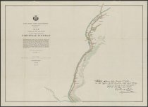
Map showing the location of the highway between Northville and Wells |
Author |
Locke, C. G. |
Digital File |
View high-resolution map image on New York Heritage database. |
Published Date |
1897 |
Object Name |
Map |
Control Number |
2018.011.0853 |
Call Number |
Map 0853 |
Publisher |
New York State Land Survey |
Physical Description |
color print encased in mylar, 31 x 22 inches |
Summary |
Color map of the Sacandaga River south of Wells. Includes note from assistant surveyor C. G. Locke to Verplanck Colvin. "Station Map No. 12, Series II." See also maps 2018.011.0835-0853. |
Search Terms |
New York (State). Adirondack Survey.; Northville (N.Y.); Wells (N.Y.); |
Imagefile |
181\20180110853.JPG |
Notes |
Transcript of verso: Sacondaga River Sheet 12 of 6-12; AA.181.6m |
Web Rights |
http://rightsstatements.org/vocab/NoC-US/1.0/ |
Collection |
General Map Collection |