Library Record
Images
Metadata
Title |
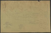
Map showing property of Forest Park & Land Company, Township 34, Town of Indian Lake, Hamilton Co. N. Y. |
Author |
Pierson, George H. |
Digital File |
View high-resolution map image on New York Heritage database. |
Published Date |
1901 |
Object Name |
Map |
Control Number |
2018.011.0130a |
Call Number |
Map 0130a |
Physical Description |
blueprint map encased in mylar, 28 x 19 inches |
Summary |
Blueprint map of Forest Park and Land Company's property as of 1901, showing Utowana, Eagle, and Blue Mountain Lakes. 1 inch = 1200 feet. W. West Durant, President. |
Search Terms |
Blue Mountain Lake (N.Y.); Durant, William West, 1850-1934.; |
Imagefile |
181\20180110130a.JPG |
Notes |
Transcript of verso: Copied by the Peerless Blue Print Co. 121 West 24th St., New York. Telephone Connection |
Web Rights |
http://rightsstatements.org/vocab/NoC-US/1.0/ |
Collection |
General Map Collection |